A powerful new digital modelling tool is helping tackle an emerging challenge in children’s health – the dramatic decline in walking and cycling to school.
Developed by researchers at The Kids Research Institute Australia and Curtin University, the NumbAT Web Platform allows urban planners, schools and families to visualise how neighbourhood infrastructure changes could shift school trips away from cars and towards active transport.
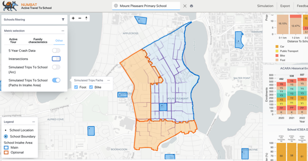
Using advanced geospatial modelling, the team has created an interactive simulation platform that shows how changes such as bike lanes, safer crossings and improved street connectivity could influence how families travel to school.
The project addresses a major public health concern. In Perth, the proportion of children walking or riding to school has fallen from around 75 per cent in the 1970s to about 20 per cent today, with most students now driven to school.
Professor Pete Gething, head of the Child Health Analytics team at The Kids and a John Curtin Distinguished Professor at Curtin University, said the project provided a practical, evidence-based way to support healthier communities.
“We built a simulator that allows us to create scenario-based cases and ask: if we improve infrastructure around school environments, what change would we expect to see in how people travel to and from school?” Professor Gething said.
The research analysed travel patterns across hundreds of metropolitan public primary schools and found car travel now accounts for more than half of school trips.
However, the modelling also revealed significant opportunities to increase active travel through targeted infrastructure improvements.
“One of the key factors influencing how children travel to school is the quality of the built environment and infrastructure around schools,” Professor Gething said.
“Even if you build bike lanes across the whole city, if families don’t perceive them as safe enough, they won’t use them.”
A key finding of the study is that school travel behaviour varied significantly between neighbourhoods, highlighting the need for tailored, local solutions rather than one-size-fits-all policies.
“Every neighbourhood is different, which means blanket policies across a city don’t always work,” Professor Gething said.
“Different schools have different surrounding infrastructure, housing density and access routes, and those factors shape how families travel.”
At the centre of the project is the NumbAT Web Platform, a publicly accessible digital tool that allows parents, schools, urban planners and policymakers to explore neighbourhood travel data and test infrastructure scenarios.
Users can visualise factors such as distance to school, route directness, intersections and traffic exposure, and simulate how improvements like bike lanes, safer crossings or traffic restrictions could influence school travel patterns.
Beyond supporting existing communities, the platform could also guide future housing developments by showing how neighbourhood design can encourage more children to walk or ride to school.
The ‘Smart Walking and Cycling: Active Travel to School Simulator’ research project was funded by a Healthway grant.
First published Thursday 21 May 2026.
View all news articles